Daha Büyük Görüntüle
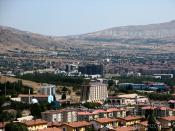
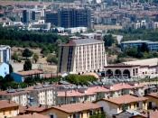
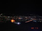
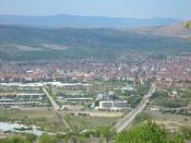
Elâzığ (Turkish pronunciation: [elaˈzɯː] or [ˈelazɯː]; Armenian: Խարբերդ; Kh'arberd/Harput, Kurdish: Xarpęt, Syriac: ܟܪܒܘܬ; Kharpuṭ) is a city in Eastern Anatolia, Turkey and the seat of Elâzığ Province. It has a population of 331,479 according to the 2010 census, and the plain on which the city extends has an altitude of 1067 metres.
Elâzığ initially developed as an extension of the historic city of Harput, which was situated on a hill and difficult to access in winter.
Name
The ancient town and citadel of Harput (Pronounced Kharberd, in Eastern Armenian, and Kharpert in Western Armenian) and meaning "rock fortress" in Armenian, was located about five kilometres from modern Elâzığ. In the early Middle Ages, it was also known by its Byzantine name, Charpete (Χάρπετε).
In the 19th century, under the reign of Mahmud II, the governor Reşid Mehmed Pasha started an expansion of Mezre, a suburb located on the plain below Kharput. During the reign of Sultan Abdülazîz, military barracks, a hospital and a governor's mansion were built to accommodate the seat of a new vilâyet (province). The town was renamed "Mamuretülaziz" (معمورة العزيز made prosperous by Aziz in Ottoman Turkish) in 1866 on the occasion of the fifth anniversary of the enthronement of Sultan Abdülaziz, although he was not the initial founder. In time the city became known as "Elâzîz" due to its ease of pronunciation. On November 17, 1937, President Mustafa Kemal Atatürk changed the name of the city to "Elazık". However, since this was hard to pronounce in Turkish, on December 10, 1937 the government changed the city's name to its final form, "Elâzığ".
History
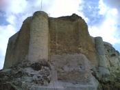
The city of Elâzığ was founded among the skirts of the hill on which the historical Harput Castle was constructed. According to the present historical sources, the most ancient inhabitants of Harput was the Hurrian nation who settled in these aprts in c2000 B.C.
Harput, and its surrounding region was part of the kingdom of Urartu at the period of its maximum extension.[3]
The ancient town and citadel called Kharput (Kharpert), which means "rocky fortress" in Armenian, was built by the first Armenian kings about five kilometers from modern Elâzığ. However, very little written material about this city reached our day. It is possible that Harput stands on or is near the site of Carcathio-certa in Sophene, reached by Corbulo in A.D. 65. The early Muslim geographers knew it as Hisn Ziyad, but the Armenian name, Khartabirt or Kharbirt, whence Kharput and Harput, was generally adopted in time.
William of Tyre wrote that Joscelin I, Count of Edessa (Jocelyn) of Courtenay, and King Baldwin II of Jerusalem were prisoners of the Amir Balak in Kharput's castle and that they were rescued by their Armenian allies. William of Tyre calls the place Quart Piert or Pierre.
Harput and its vicinity fell under Turkish control in the year 1085 as the outcome of the Malazgirt battle August,26 in 1071. The Çubukoğulları, Artuqids, Aq Qoyuns and Ottomans had reigned in the region[4]
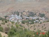
Harput is still partly settled today, but due to its high elevation and lack of water it is slowly in the process of being abandoned, with most of its residents moving to Elâzığ. Harput still has a few thousand inhabitants.
Christian communities
According to tradition, the Mart Maryam Church, a (Syriac Orthodox) sanctuary, was the first church in Harput, built in 179 A.D.
Harput was the seat of a Syrian Orthodox bishop as early as the eleventh century, whose diocese was initially called Hisn Ziyad and later Harput. The last Syrian Orthodox bishop of Harput, Cyril Mansur, was murdered along with many of the town's Christians during the Armenian Genocide and Assyrian Genocide of 1915.[5]
An Armenian Catholic diocese of Kharput was created in 1850.
Elâzığ under the Republic of Turkey
Year Population
1914 10,000 - 12,000
1927 20,052
1940 25,465
1945 23,695
1950 29,317
1955 41,667
1960 60,289
1965 78,605
1970 107,364
1975 131,415
2008 389,774
From its foundation until the end of the World War II, the city's growth was somewhat irregular. While the town probably consisted of 10 to 12,000 inhabitants at the beginning of the World War I, the first census conducted by the Republic of Turkey in 1927 counted 20,052 inhabitants. This figure continued to rise to reach 25,465 in 1940, but the general shortages suffered during the World War II years by the neutral Turkey led to an exodus of population, reducing the population to 23,635. From then onward, the city has gone through uninterrupted growth. Harput, in the meantime, acquired the status of a township separated from Elâzığ with a population running around two thousand souls.
Economy
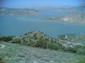
The most important factor affecting the growth of Elâzığ since the 1970s has been the construction of Keban Dam and the hydroelectric power plant (5,871,000 kwh/year) with its boulder at a distance of 45 km from the city and the resulting huge dam reservoir. This reservoir covers an area of 68,000 hectares and it flooded around a hundred villages with a hundred others losing a large part of their agricultural lands. Around 20,000 people were forced to move as a consequence of the dam's construction.
Industries connected with the dam such as a cement mill contributed to the growth and, as Ayalon and Sharon points out, to a striking gap between the male and female populations in Elâzığ, the former outnumbering the latter by some eight thousand throughout the seventies, which was a consequence of the move into and settlement in the city of workers employed in the construction effort.
Many of those who were forced to move with the construction of the dam chose to settle in Elâzığ center and the state indemnities paid were invested in houses in Elâzığ or laid a base for small businesses. However, the Keban Dam affected more than 30,000 people and at least 212 villages. Over 80% of families in zones affected by the Keban dam were landless peasants and thus ineligible to receive compensation or peasants with little land who would receive very little money (Koyunlu 1982: 250)
The region of Elâzığ has much mineral wealth, a healthy climate and a fertile soil. Extraction of chrome is an important mining activity.
The dam, the industry and the mining accounts for the high level of urbanization (42.7% in 1970) surpassing the average levels for Eastern Anatolia.
The main agricultural activity of the area centers around vineyards and Elâzığ also serves as a market hub for other agricultural products. The state-run vineyards of Elâzığ is notable for its production of Buzbağ, a full-flavored red wine.
Elâzığ today is the capital of the Elâzığ province, a bustling city with a university and an industrial base, although historic monuments are understandably scarce. The exception is of course the ancient Harput citadel and town, a dependency of the greater municipality of Elâzığ today situated three miles to the north of the city center. The population of Elâzığ consists of Turks, Kurds and Azeris.[citation needed]
Geography
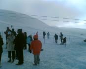
Elâzığ is situated at the northwestern corner of a 30-mile-long valley, known locally as Uluova (literally the Great Valley). The area's Armenians called this valley "Vosgetashd" (the Golden Plain). Its altitude is 3,300 feet: latitude and longitude are respectively: 38 degrees and 41 minutes North, and 39 degrees and 14 minutes East. Elâzığ Province is surrounded by the Euphrates in the north, and since the completion of Keban Dam the rivers came to cover almost ten percent of the surface area (826 km˛) of the province (8,455 km˛). Elâzığ's adjacent province borders are with: Tunceli (North), Erzincan (North-West), Bingöl (East), Diyarbakır (South), and Malatya (West).
Source |