Daha Büyük Görüntüle
Honolulu, Hawaii
— State Capital —
City of Honolulu
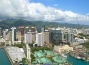
Clockwise: Aerial view of Downtown Honolulu, Pearl Harbor right outside the city, statue of King Kamehameha I in downtown, Diamond Head, waterfront on Waikiki Beach, and Honolulu Hale (City Hall)
Flag
Seal
Nickname(s): Crossroads of the Pacific, Sheltered Bay, The Big Pineapple, Paradise
Motto: Haʻaheo No ʻO Honolulu (The Pride of Honolulu)[1]
Location in Honolulu County and the state of Hawaii
Honolulu is located in Hawaii
Honolulu, Hawaii
Location in Honolulu County and the state of Hawaii
Coordinates: 21°18′32″N 157°49′34″WCoordinates: 21°18′32″N 157°49′34″W
Country United States
State Hawaii Hawaii
County Honolulu
Incorporated April 30, 1907[2]
Government
• Mayor Peter Carlisle
• Honolulu City Council
Members[show]
Area[3]
• State Capital 68.4 sq mi (177.2 km2)
• Land 60.5 sq mi (156.7 km2)
• Water 7.9 sq mi (20.5 km2)
Elevation 19 ft (6 m)
Population (2010)
• State Capital 337,256 (53rd)
• Density 5,574/sq mi (2,152.2/km2)
• Metro 953,207
Time zone HAST (UTC−10)
Zip Code 96801-96850
Area code(s) 808
FIPS code 15-17000
GNIS feature ID 0366212
Honolulu (play /ˌhɒnəˈluːluː/[4] or /ˌhoʊnoʊˈluːluː/;[5] Hawaiian: [hono'lulu]) is the capital and the most populous city of the U.S. state of Hawaii.a[›] Honolulu is the southernmost major U.S. city. Although the name "Honolulu" refers to the urban area on the southeastern shore of the island of Oahu, the city and county government are consolidated as Honolulu County which covers the entire island. For statistical purposes, the U.S. Census Bureau recognizes the urban part of Honolulu as a census-designated place (CDP).[6] Honolulu is a major financial center of the islands of the Pacific Ocean. The population of the census-designated place was 337,256 at the 2010 census,[7] while the population of the city and county was 953,207. Honolulu is the most populous state capital relative to state population.
In the Hawaiian language, Honolulu means "sheltered bay" or "place of shelter". The old name is said to be Kou, a district roughly encompassing the area from Nuuanu Avenue to Alakea Street and from Hotel Street to Queen Street which is the heart of the present downtown district.[8] The city has been the capital of the Hawaiian islands since 1845 and gained historical recognition following the Japanese attack on Pearl Harbor near the city on December 7, 1941.
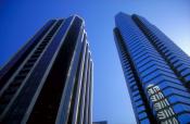
Honolulu has a large skyline. As of April 2012, the city had over 470 high rises, which is ranked fourth in the United States behind New York City, Chicago, and Los Angeles. Similar to New York City and Chicago, highrises are located in more than just the downtown area; neighboring and nearby neighborhoods, including Ala Moana and Waikiki, include large clusters of office, residential, and hotel high-rises, extending from Downtown all the way to Diamond Head.[9]
Port of Honolulu, as seen by Russian artist Louis Choris in 1816
Queen Street, Honolulu, 1856, by George Henry Burgess
people in street watching fire in distance
The Great Chinatown Fire
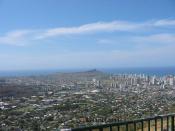
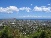
View of downtown from Punchbowl Crater
Evidence of the first settlement of Honolulu by the original Polynesian migrants to the archipelago comes from oral histories and artifacts. These indicate that there was a settlement where Honolulu now stands in the 11th century.[10] However, after Kamehameha I conquered Oʻahu in the Battle of Nuʻuanu at Nuʻuanu Pali, he moved his royal court from the Island of Hawaiʻi to Waikīkī in 1804. His court relocated in 1809 to what is now downtown Honolulu.[11] The capital was moved back to Kailua-Kona in 1812.
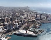
In 1794, Captain William Brown of Great Britain was the first foreigner to sail into what is now Honolulu Harbor.[12] More foreign ships followed, making the port of Honolulu a focal point for merchant ships traveling between North America and Asia.[13]
In 1845, Kamehameha III moved the permanent capital of the Hawaiian Kingdom from Lahaina on Maui to Honolulu. He and the kings that followed him transformed Honolulu into a modern capital,[14] erecting buildings such as St. Andrew's Cathedral, ʻIolani Palace, and Aliʻiōlani Hale. At the same time, Honolulu became the center of commerce in the islands, with descendants of American missionaries establishing major businesses in downtown Honolulu.[15]
Despite the turbulent history of the late 19th century and early 20th century, such as the overthrow of the Hawaiian monarchy in 1893, Hawaiʻi's subsequent annexation by the United States in 1898, followed by a large fire in 1900, and the Japanese attack on Pearl Harbor in 1941, Honolulu remained the capital, largest city, and main airport and seaport of the Hawaiian Islands.[16]
An economic and tourism boom following statehood brought rapid economic growth to Honolulu and Hawaiʻi. Modern air travel brings, as of 2007, 7.6 million visitors annually to the islands, with 62.3% entering at Honolulu International Airport.[17] Today, Honolulu is a modern city with numerous high-rise buildings, and Waikīkī is the center of the tourism industry in Hawaiʻi, with thousands of hotel rooms. The UK consulting firm Mercer, in a 2009 assessment "conducted to help governments and major companies place employees on international assignments", ranked Honolulu 29th worldwide in quality of living; the survey factored in political stability, personal freedom, sanitation, crime, housing, the natural environment, recreation, banking facilities, availability of consumer goods, education, and public services including transportation.[18]
Geography
Astronaut Photography of Honolulu Hawaii taken from the International Space Station (ISS)
According to the United States Census Bureau, the CDP has a total area of 68.4 square miles (177.2 km2). 60.5 square miles (156.7 km2) of it is land, and 7.9 square miles (20.5 km2) of it (11.56%) is water.[19]
The closest location on the mainland to Honolulu is the Point Arena, California Lighthouse, at 2,045 nautical miles (3,787 km).[20] (Nautical vessels require some additional distance to circumnavigate Makapu'u Point.) However, part of the Aleutian Islands of Alaska are slightly closer to Honolulu than the mainland.
Climate
Honolulu experiences a tropical savanna climate (Köppen classification As) with a mostly dry summer season due to a rainshadow effect that suppresses summer rains. Honolulu has lots of sunshine most of the year. Temperatures vary little throughout the months, with average high temperatures of 80–90 °F (27–32 °C) and average lows of 65–75 °F (18–24 °C) throughout the year. Temperatures rarely exceed 95 °F (35 °C), with lows in the upper 50s °F (14–15 °C) occurring once or twice a year. The highest recorded temperature was 95 °F (35 °C) during a heat wave in September 1998. The highest recorded temperature in the state was also recorded later that day in Ni'ihau. The lowest recorded temperature was 52 °F (11 °C) on February 16, 1902 and January 20, 1969. Waters off the coast of Honolulu average 81 °F (27 °C) in the summer months and 77 °F (25 °C) in the winter months.[citation needed]
Annual average rain is 21.1 in (540 mm), which mainly occurs during the winter months of October through early April, with very little rainfall during the summer. Honolulu has an average of 278 sunny days and 90 wet days per year. Although Honolulu is known to have a wet and dry season, it is unnoticeable. This is mainly because light showers fall in the summer while heavier rain falls during the winter. Yet, both seasons experience the same amount of rainy days.
Although the city is situated at the tropics, hurricanes are quite rare. The last recorded hurricane that hit the city was Category 4 Hurricane Iniki in 1992. Tornadoes are also uncommon and usually hit once every 15 years. Watersprouts off the coast are somewhat more common, hitting about once every five years
Government
Completed in 1928, Honolulu Hale is the city and county seat
Peter Carlisle has served as the 13th mayor of Honolulu since October 11, 2010. The municipal offices of the City and County of Honolulu, including Honolulu Hale, the seat of the city and county, are located in the Capitol District, as are the Hawaii state government buildings.[24]
The Capitol District is within the Honolulu Census County Division (CCD). The Honolulu CCD is located on the southeast coast of Oahu between Makapuu and Halawa. The division boundary follows the Koolau crestline, so Makapuʻu Beach is in the Koolaupoko District. On the west, the division boundary follows Halawa Stream, then crosses Red Hill and runs just west of Aliamanu Crater, so that Aloha Stadium, Pearl Harbor (with the USS Arizona Memorial), and Hickam Air Force Base are actually all located in the island's Ewa CCD.[25]
The Hawaii Department of Public Safety operates the Oahu Community Correctional Center, the jail for the island of Oahu, in Honolulu CCD.[26]
The United States Postal Service operates post offices in Honolulu CDP. The main Honolulu Post Office is located by the international airport at 3600 Aolele Street.[27] Federal Detention Center, Honolulu, operated by the Federal Bureau of Prisons, is in the CDP.[28]
Diplomatic missions
Several countries have diplomatic facilities in Honolulu CDP in the City and County of Honolulu. They include consulates of Japan,[29] South Korea,[30] Philippines,[31] Federated States of Micronesia,[32] Australia,[33] and the Marshall Islands.[34]
Neighborhoods and districts
Honolulu as seen from the International Space Station
Downtown at Bishop and King streets, with First Hawaiian Center (left) and Bankoh Center (right)
Downtown Honolulu is the financial, commercial, and governmental center of Hawaii. On the waterfront is Aloha Tower, which for many years was the tallest building in Hawaii. Currently the tallest building is the 438-foot (134 m) tall First Hawaiian Center, located on King and Bishop Streets. The downtown campus of Hawaii Pacific University is also located there.
The Arts District Honolulu in downtown/Chinatown is on the eastern edge of Chinatown. It is a 12-block area bounded by Bethel & Smith Streets and Nimitz Highway and Beretania Street – home to numerous arts and cultural institutions. It is located within the Chinatown Historic District, which includes the former Hotel Street Vice District.[35]
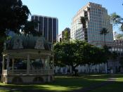
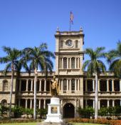
The Capitol District is the eastern part of Downtown Honolulu. It is the current and historic center of Hawaii's state government, incorporating the Hawaii State Capitol, Iolani Palace, Honolulu Hale (City Hall), State Library, and the statue of King Kamehameha I, along with numerous government buildings.
Kakaʻako is a light-industrial district between Downtown and Waikīkī that has seen a large-scale redevelopment effort in the past decade. It is home to two major shopping areas, Ward Warehouse and Ward Centre. The John A. Burns School of Medicine, part of the University of Hawaiʻi at Manoa is also located there. A Memorial to the Ehime Maru Incident victims is built at Kakaako Waterfront Park.
Ala Moana is a district between Kakaʻako and Waikīkī and the home of Ala Moana Center, the "World's largest open air shopping center" and the largest shopping mall in Hawaii.[36] Ala Moana Center boasts over 300 tenants and is a very popular location among tourists. Also in Ala Moana is the Honolulu Design Center and Ala Moana Beach Park, the second largest park in Honolulu.
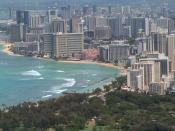
Waikīkī is the tourist district of Honolulu, located between the Ala Wai Canal and the Pacific Ocean next to Diamond Head. Numerous hotels, shops, and nightlife opportunities are located along Kalakaua and Kuhio Avenues. It is a popular location for visitors and locals alike and attracts millions of visitors every year. A majority of the hotel rooms on Oahu are located in Waikīkī.
Manoa and Makiki are residential neighborhoods located in adjacent valleys just inland of downtown and Waikīkī. Manoa Valley is home to the main campus of the University of Hawaiʻi. President Barack Obama lived in Makiki with his maternal grandparents until graduating from Punahou School, apart from four years in Indonesia with his mother and stepfather.
Nuʻuanu and Pauoa are upper-middle-class residential districts located inland of downtown Honolulu. The National Memorial Cemetery of the Pacific is located in Punchbowl Crater fronting Pauoa Valley.
Palolo and Kaimuki are neighborhoods east of Manoa and Makiki, inland from Diamond Head. Palolo Valley parallels Manoa and is a residential neighborhood. Kaimuki is primarily a residential neighborhood with a commercial strip centered on Waialae Avenue running behind Diamond Head. Chaminade University is located in Kaimuki.
Waialae and Kahala are upper-class districts of Honolulu located directly east of Diamond Head, where there are many high-priced homes. Also found in these neighborhoods are the Waialae Country Club and the five-star Kahala Hotel & Resort.
East Honolulu includes the residential communities of ʻĀina Haina, Niu Valley, and Hawaiʻi Kai. These are considered upper-middle-class neighborhoods. The upscale gated communities of Waiʻalae ʻiki and Hawaiʻi Loa Ridge are also located here.
Kalihi and Palama are working-class neighborhoods with a number of government housing developments. Lower Kalihi, toward the ocean, is a light-industrial district.
Salt Lake and Aliamanu are (mostly) residential areas built in extinct tuff cones along the western end of the Honolulu District, not far from the Honolulu International Airport.
Moanalua is two neighborhoods and a valley at the western end of Honolulu, and home to Tripler Army Medical Center.
Air
Honolulu International Airport old control tower
8R "Reef Runway" of Honolulu International Airport
Aerial view of H-1 (looking east) from Honolulu Airport heading into downtown Honolulu
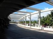
Located on the western end of the CDP, Honolulu International Airport (HNL) is the principal aviation gateway to the state of Hawaii. Kalaeloa Airport is primarily a commuter facility used by unscheduled air taxis, general aviation and transient and locally based military aircraft.
Highways
Honolulu has been ranked as having the nation’s worst traffic congestion, beating former record holder Los Angeles. Drivers waste on average over 58 hours per year on congested roadways.[48] The following freeways, part of the Interstate Highway System serve Honolulu:
I-H1.svg Interstate H-1, which, coming into the city from the west, passes Hickam Air Force Base and Honolulu International Airport, runs just north of Downtown and continues eastward through Makiki and Kaimuki, ending at Waialae/Kahala. H-1 connects to Interstate H-2 from Wahiawa and Interstate H-3 from Kaneohe, west of the CDP.
I-H201.svg Interstate H-201—also known as the Moanalua Freeway and sometimes numbered as its former number, Hawaii State Rte. 78—connects two points along H-1: at Aloha Stadium and Fort Shafter. Close to H-1 and Aloha Stadium, H-201 has an exchange with the western terminus of Interstate H-3 to the windward side of Oahu (Kaneohe). This complex of connecting ramps, some directly between H-1 and H-3, is in Halawa.
Other major highways that link Honolulu proper with other parts of the Island of Oahu are:
Pali Highway, State Rte. 61, crosses north over the Koolau range via the Pali Tunnels to connect to Kailua and Kaneohe on the windward side of the Island.
Likelike Highway, State Rte. 63, also crosses the Koolau to Kaneohe via the Wilson Tunnels.
Kalanianaole Highway, State Rte. 72, runs eastward from Waialae/Kahala to Hawaii Kai and around the east end of the island to Waimanalo Beach.
Kamehameha Highway, State Rts. 80, 83, 99 and 830, runs westward from near Hickam Air Force Base to Aiea and beyond, eventually running through the center of the island and ending in Kaneohe.
Like most major American cities, the Honolulu metropolitan area experiences heavy traffic congestion during rush hours, especially to and from the western suburbs of Kapolei, 'Ewa Beach, Aiea, Pearl City, Waipahu, and Mililani.
There is a Hawaii Electric Vehicle Demonstration Project (HEVDP).[49]
Public transport
Honolulu Authority for Rapid Transportation
In November 2010, voters approved a charter amendment to create a public transit authority to oversee the planning, construction, operation and future extensions to Honolulu's future rail system (see below). Operations began on July 1, 2011. The Honolulu Authority for Rapid Transportation (HART) currently includes a 10-member board of directors; three members appointed by the mayor, three members selected by the Honolulu City Council, and the city and state transportation directors.[50]
Bus
Main article: TheBus (Honolulu)
Established by former Mayor Frank F. Fasi as the replacement for the Honolulu Rapid Transit Company (HRT), Honolulu's TheBus system has been twice honored by the American Public Transportation Association bestowing the title of "America's Best Transit System" for 1994–1995 and 2000–2001. TheBus operates 107 routes serving Honolulu and most major cities and towns on Oahu. TheBus comprises a fleet of 531 buses, and is run by the non-profit corporation Oahu Transit Services in conjunction with the city Department of Transportation Services. Honolulu is ranked 4th for highest per-capita use of mass transit in the United States.[51]
Rail
Main article: Honolulu High-Capacity Transit Corridor Project
Currently, there is no urban rail transit system in Honolulu, although electric street railways were operated in Honolulu by the now-defunct Honolulu Rapid Transit Company prior to World War II. Predecessors to the Honolulu Rapid Transit Company were the Honolulu Rapid Transit and Land Company (began 1903) and Hawaiian Tramways (began 1888).[52]
The City and County of Honolulu is currently constructing a 20-mile (32 km) rail transit line that will connect Honolulu with cities and suburban areas near Pearl Harbor and in the Leeward and West Oahu regions. The Honolulu High-Capacity Transit Corridor Project is aimed at alleviating traffic congestion for West Oahu commuters while being integral in the westward expansion of the metropolitan area. The project however has been criticized for its cost, delays, and potential environmental impacts.
Cultural institutions
With symbolic native-styled architectural features, First Hawaiian Center is the tallest building in Hawaii and home to a Contemporary Museum gallery
Natural museums
The Bishop Museum is the largest of Honolulu's museums. It is endowed with the state's largest collection of natural history specimens and the world's largest collection of Hawaiiana and Pacific culture artifacts.[53] The Honolulu Zoo is the main zoological institution in Hawaii while the Waikiki Aquarium is a working marine biology laboratory. The Waikiki Aquarium is partnered with the University of Hawaii and other universities worldwide. Established for appreciation and botany, Honolulu is home to several gardens: Foster Botanical Garden, Liliʻuokalani Botanical Garden, Walker Estate, among others.
Performing arts
Established in 1900, the Honolulu Symphony is the oldest US symphony orchestra west of the Rocky Mountains. Other classical music ensembles include the Hawaii Opera Theatre. Honolulu is also a center for Hawaiian music. The main music venues include the Hawaii Theatre, the Neal Blaisdell Center Concert Hall and Arena, and the Waikiki Shell.
Honolulu also includes several venues for live theater, including the Diamond Head Theatre.
Visual arts
Various institutions for the visual arts are located in Honolulu.
The Honolulu Museum of Art is endowed with the largest collection of Asian and Western art in Hawaii. It also has the largest collection of Islamic art, housed at the Shangri La estate. The museum hosts a film and video program dedicated to arthouse and world cinema in the museum's Doris Duke Theatre, named for the museum's historic patroness Doris Duke.[citation needed]
The Contemporary Museum is the only contemporary art museum in the state. It has two locations: main campus in Makiki and a multi-level gallery in downtown Honolulu at the First Hawaiian Center.
The Hawaii State Art Museum (also downtown) boasts pieces by local artists as well as traditional Hawaiian art. The museum is administered by the Hawaii State Foundation on Culture and the Arts.
Honolulu also annually holds the Hawaii International Film Festival (HIFF). It showcases some of the best films from producers all across the Pacific Rim and is the largest "East meets West" style film festival of its sort in the United States.
Sports
Honolulu's climate lends itself to year-round activities. In 2004, Men's Fitness magazine named Honolulu the fittest city in the United States.[54] Honolulu has three large road races:
The Great Aloha Run is held annually on Presidents' Day.
The Honolulu Marathon, held annually on the second Sunday in December, draws more than 20,000 participants each year, about half to two thirds of them from Japan.
The Honolulu Triathlon is an Olympic distance triathlon event governed by USA Triathlon. Held annually in May since 2004, there is an absence of a sprint course.
Ironman Hawaii was first held in Honolulu, it was the first ever Ironman and is also the World Champs.
Fans of spectator sports in Honolulu generally support the football, volleyball, basketball, rugby union, rugby league and baseball programs of the University of Hawaii at Manoa.[55] High school sporting events, especially football, are especially popular.
Honolulu has no professional sports teams. It was the home of the Hawaii Islanders (Pacific Coast League, 1961–1987), The Hawaiians (World Football League, 1974–1975), Team Hawaii (North American Soccer League, 1977), and the Hawaiian Islanders (af2, 2002–2004).
The NCAA football Hawaii Bowl is played in Honolulu. Honolulu has also hosted the NFL's annual Pro Bowl each February since 1980, though the 2010 Pro Bowl was played in Miami.[56] In 2011, the 2011 Pro Bowl returned once again to Honolulu. From 1993 to 2008, Honolulu hosted Hawaii Winter Baseball, featuring minor league players from Major League Baseball, Nippon Professional Baseball, Korea Baseball Organization, and independent leagues.
Source |