Daha Büyük Görüntüle
Giresun
Coat of arms
Giresun is located in Turkey
Giresun
Coordinates: 40°54′55″N 38°23′22″ECoordinates: 40°54′55″N 38°23′22″E
Country Turkey
Province Giresun
Government
• Mayor Kerim Aksu (CHP)
• Kaymakam
Area
• District 296 km2 (114 sq mi)
Elevation 10 m (30 ft)
Population (2008)[1][2]
• Urban 90,034
• District 116,310
• District Density 390/km2 (1,000/sq mi)
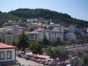
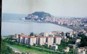
Giresun (pronounced [ɡiɾeˈsun]; Turkish: Giresun, Ancient Greek: Pharnacia, Choerades) is the provincial capital of Giresun Province in the Black Sea Region of northeastern Turkey, about 175 km (109 mi) west of the city of Trabzon.
Etymology
Giresun was known to the ancient Greeks as Choerades or Pharnacia and later as Kerasous or Cerasus, < Kerason < Kerasounta < Keras "horn" (for peninsula) in Greek + ounta, a Greek toponomical suffix.[3] Öztürk claims that Cape Zephyros settlement oldest than the Kerasus or Pharnakia and its Greek name Giraprinos or Yero Prinos (γέρο πρίνος) "Old Oak" basic translation of the native Kolchian/Laz name [4] The name later mutated into Kerasunt (sometimes written Kérasounde or Kerassunde).
The English word cherry, French cerise, Spanish cereza, and Southern Italian dialect cerasa (standard Italian ciliegia) all come from Classical Greek κερασός "cherry tree", which has been identified with Cerasus. The cherry was first exported to Europe from Cerasus in Roman times, according to Pliny by Lucullus.
Geography
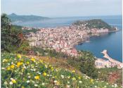
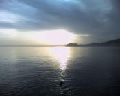
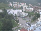
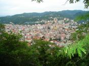
The surrounding region has a rich agriculture, growing most of Turkey's hazelnuts as well as walnuts, cherries, leather and timber, and the port of Giresun has long handled these products. The harbour was enlarged in the 1960s and the town is still a port and commercial centre for the surrounding districts, but Giresun is not large, basically one avenue of shops leading away from the port.
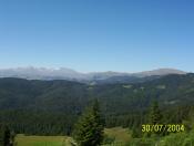
Like everywhere else on the Black Sea coast it rains (and often snows in winter) and is very humid throughout the year, with a lack of extreme temperatures both in summer and winter. As a result Giresun and the surrounding countryside is covered by luxuriant flora. As soon as you get beyond the city buildings you get into the hazelnut growing area and the high pastures (yayla) further in the mountains are gorgeous.
History
Giresun city at the beginng of 1900's
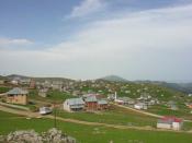
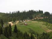
Pınarlar village, Giresun
Aksu stream, Giresun
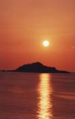
Giresun's history goes back to the late 6th century BC, when it was founded by Greek colonists from Sinope, 110 km east of the homonymous city founded by Pharnakes I of Pontus, using citizens transferred from Kotyora, ca 180 BC.[6] The name of the city is first cited in the book Anabasis by Xenophon as Kerasus. Historic records reveal that the city was dominated by the Miletians, Persians, Romans, Byzantines and Empire of Trebizond. The older parts of the city lie on a peninsula crowned by a ruined Byzantine fortress, sheltering the small natural harbour. Nearby is Giresun Island, in ancient times called Aretias, the only major Black Sea island in Turkish territory. According to legend, the island was sacred to the Amazons, who had dedicated a temple to the war god Ares here. Even today, fertility rites are performed here every May, now shrouded as a popular practice, but really a 4,000 year old celebration. During the medieval period Kerasunt was part of the Byzantine Empire and later the second city of the Empire of Trebizond. From 1244 onwards the Seljuk Turks moved into the area, pursued at times by the Mongol hordes until in 1461 the whole of this coast was brought within the Ottoman Empire by Sultan Mehmet II. She was shortly occupied by Emirate of Hacıemiroğlu (Emirate of Chalybia) between 1398-1400.
The victory of Alexios II over the Turkmen ‘Koustoganes" at Kerasus in September 1301 was vitally important. If Kerasus had fallen in 1301, the Turkmen would have obtained major access to the sea and the days of the Trapezuntine Empire would have been numbered. After 1301, Alexios II built a fortress which overlooks the sea.
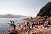
4.2 km east-northeast of Kerasus is a fortified island called Ares (Αρητιας νήσος or Αρεώνησος). It was here according to Apollonius of Rhodes, that the Argonauts encountered both the Amazons and a flock of vicious birds. The Greeks of the island held out against the Ottomans for 7 years after the fall of Trapezus 1461.
Source |