Daha Büyük Görüntüle
Kayseri
— City —
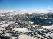
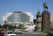
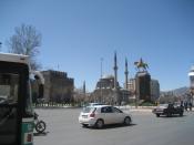
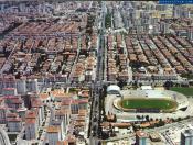
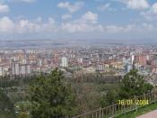
A view from central Kayseri
Kayseri is located in Turkey
Kayseri
Location of Kayseri, Turkey
Coordinates: 38°44′N 35°29′ECoordinates: 38°44′N 35°29′E
Country Turkey
Region Central Anatolia
Province Kayseri
Government
• Mayor Mehmet Özhaseki (AKP)
Elevation 1,050 m (3,440 ft)
Population (2011)[1][2]
• City 844,656
• Metro 977,240
Time zone EET (UTC+2)
• Summer (DST) EEST (UTC+3)
Postal code 38x xx
Area code(s) (+90) 352
Licence plate 38
Kayseri (pronounced [kajˈseɾi]) is a large and industrialized city in Central Anatolia, Turkey. It is the seat of Kayseri Province. The city of Kayseri, as defined by the boundaries of Kayseri Metropolitan Municipality, is structurally composed of five metropolitan districts, the two core districts of Kocasinan and Melikgazi, and since 2004, also Hacılar, İncesu and Talas. In conjunction with the addition of new districts and first stage municipalities into the metropolitan area, the city's population, which was 536,000 in 2000, was 1,050,000 in 2011. Kayseri is located at the foot of the extinct volcano Mount Erciyes that towers 3916 m over the city. Its inhabitants (Kayserili) are renowned for their alertness, entrepreneurial spirit and a strict understanding regarding the management of economies, the last point having been the subject of more than a few legends in Turkey.wealth of the city itself is a blend of modernity and conservatism. The city is often cited in the first ranks among Turkey's cities that fit the definition of Anatolian Tigers.[3]
Renowned for its culinary specialties such as mantı, pastırma and sucuk, the city is also rich in historical monuments (dating especially from the Seljuk period). While it is generally visited en-route to the international tourist attractions of Cappadocia, Kayseri has many visitor's attractions by its own right; Seljuk and Ottoman era monuments in and around the center, Mount Erciyes as trekking and alpinism center, Zamantı River as rafting center, the historic sites of Kültepe, Ağırnas, Talas and Develi to name a few. Kayseri is served by Erkilet International Airport and is home to Erciyes University.
According to the Turkish Statistical Institute, as of 2011 the city of Kayseri had a population of 844,656 and its metropolitan municipality 977,240.[1][2]
Etymology
Kayseri was originally called Mazaka or Mazaca by the Hattians and was known as such to Strabo, during whose time it was the capital of the Roman province of Cilicia, known also as Eusebia at the Argaeus (Εὐσέβεια ἡ πρὸς τῶι Ἀργαίωι in Greek), after Ariarathes V Eusebes, King of Cappadocia (163–130 BCE). The name was changed again by Archelaus (d. 17 CE), last King of Cappadocia (36 BCE–14 CE) and a Roman vassal, to "Caesarea in Cappadocia" (to distinguish it from other cities with the name Caesarea in the Roman Empire) in honour of Caesar Augustus, upon his death in 14 CE. When the Muslim Arabs arrived, they slightly modified the name into Kaisariyah, and this eventually became Kayseri when the Seljuk Turks took control of the city in circa 1080 CE, remaining as such ever since.[4]
History
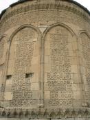
Door detail from the Seljuk era Hunat Hatun Mosque and Külliye, built in 1238 by Sultana Hunat Hatun, wife of the Anatolian Seljuk Sultan Alaeddin Keykubad I and mother of Sultan Gıyaseddin Keyhüsrev II.
The city has been continuously lived since 3000 BCE with the establishment of the ancient trading colony at Kultepe (Ash Mountain) which is associated with the Hittites. The city has always been a vital trade centre as it is located on major trade routes, particularly along what was called the Great Silk Road. Kültepe, one of the oldest cities in Asia Minor, lies nearby.
As Mazaca, the city served as the residence of the kings of Cappadocia. In ancient times, it was on the crossroads of the trade routes from Sinope to the Euphrates and from the Persian Royal Road that extended from Sardis to Susa. In Roman times, a similar route from Ephesus to the East also crossed the city.
The city stood on a low spur on the north side of Mount Erciyes (Mount Argaeus in ancient times). Only a few traces of the ancient site survive in the old town. The city was the centre of a satrapy under Persian rule until it was conquered by Perdikkas, one of the generals of Alexander the Great when it became the seat of a transient satrapy by another of Alexander's former generals, Eumenes of Cardia. The city was subsequently passed to the Seleucid empire after the battle of Ipsus but became once again the centre of an autonomous Greater Cappadocian kingdom under Ariarathes III of Cappadocia at around 250BC. In the ensuing period, the city came under the sway of Hellenistic influence, and was given the Greek name of Eusebia in honor of the Cappadocian king Ariarathes V Eusebes Philopator of Cappadocia (163–130 BCE). Under the new name of Caesarea, by which it has since been known, given to it by the last Cappadocian King Archelaus[4] or perhaps by Tiberius,[5] the city passed under formal Roman rule in 17BCE.
Caesarea was destroyed by the Sassanid king Shapur I after his victory over the Emperor Valerian I in 260. At the time it was recorded to have around 400,000 inhabitants. The city gradually recovered and, indeed, became a home to several early Christian saints: saints Dorothea and Theophilus the martyrs, Gregory of Nazianzus, Gregory of Nyssa and Basil of Caesarea. In the 4th century, bishop Basil established an ecclesiastical centre on the plain, about one mile to the northeast, which gradually supplanted the old town. In it Basil included a system of almshouses, an orphanage, old peoples' homes and a leprosarium, a leprosy hospital. A portion of Basil's new city was surrounded with strong walls and turned into a fortress by Justinian. Caesarea became in the 9th century a Byzantine administrative centre as the capital of the Byzantine Theme of Charsianon.
Walls of the Seljuk era Sahabiye Medresesi, built in 1267 by the Seljuk vizier Sahip Ata Fahreddin Ali.
The Arab general (and later the first Umayyad Caliph) Muawiyah invaded Cappadocia and took Caesarea from the Byzantines temporarily in 647.[6] The city was called Kaisariyah by the Arabs and later Kayseri[4] when it was captured by the Seljuk sultan Alp Arslan in 1064. It became one of the most prominent centers of initially the Danishmendids (1074–1178), and later the Anatolian Seljuk Sultanate (1178–1243), until it fell to the Mongols in 1243. Within the walls lies the greater part of Kayseri rebuilt between the 13th and 16th centuries. The city became Ottoman in the 15th century.
Thus, there were three golden-age periods for Kayseri. The first, dating back to 2000 BCE, was when the city was a trade post between the Assyrians and the Hittites. The second golden age came during the Roman rule (1st-11th C). The third golden age was during the reign of Seljuks (1178–1243), when the city was the second capital of the state.
Kayseri Castle walls in 2006.
View of the castle from the main square.
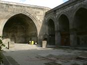
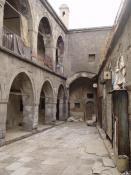
The 1500-year-old castle, built initially by the Byzantines and expanded by the Seljuks and Ottomans, is still standing in good condition in the central square of the city. The short-lived Seljuk rule left large number of historical landmarks; historical buildings such as the Hunad Hatun Mosque complex, Kilij Arslan[disambiguation needed] Mosque, The Grand Mosque[disambiguation needed] and Gevher Nesibe Hospital. The Grand Bazaar dates from the latter part of the 1800s, but the adjacent caravanserai (where merchant traders gathered before forming a caravan) dates from around 1500. The town's older districts (which were filled with ornate mansion-houses mostly dating from the 18th and 19th centuries) were subjected to wholesale demolitions starting in the 1970s.[7] The city is famous for its carpet sellers, and a range of carpets and rugs can be purchased reasonably ranging from new to 50 or more years old.
In the 4th century the city became central to early Christianity when St. Basil the Great established an ecclesiastical centre here.[8] It is a Roman Catholic titular see[9] and was the seat of an Armenian diocese.[10]
The building that hosts the Kayseri lyceum was arranged to host the Turkish Grand National Assembly during the Turkish War of Independence when the Greek army had advanced very close to Ankara, the base of the Turkish National Movement.
Economy
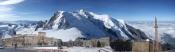
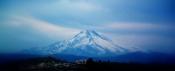
Mount Erciyes near Kayseri is a popular destination for winter sports.
Kayseri received notable public investments in the 1920s and 1930s. Sumer Textile and Kayseri Tayyare Fabrikasi (airplane manufacturer) were set up here during the post Republican Era with the help of German and particularly Russian experts. The latter manufactured the first aircraft "made in Turkey" in the 1940s. After the 1950s, the city suffered from a decrease in the amount of public investment. It was, however, during the same years that Kayseri businessmen and merchants became transformed into countrywide capitalists. Families such as Sabancı, Has, Dedeman, Hattat, Kurmel, Özyeğin, Karamanlargil and Ozilhan who started out as small-scale merchants in the city of Kayseri became prominent actors in the Turkish economy. These families set up their headquarters in cities such as Istanbul and Adana, nevertheless often coming back to Kayseri to invest.
Thanks to the economic liberalization policies introduced in the 1980s, a new wave of merchants and industrialists from Kayseri joined their predecessors. Most of these new industrialists choose Kayseri as base of their operations. As a consequence of better infrastructures, the city achieved a remarkable industrial growth since 2000 and is one of the key cities that characterizes the class of Anatolian Tigers, with a favorable environment present especially for small and medium enterprises. Some social scientists trace this economic success to a modernist Islamic outlook referred to as "Islamic Calvinism" which they say is taking root in Kayseri.[13]
Transport
Erkilet International Airport
The city is served by Erkilet International Airport and the International Air Transport Association symbol for the airport is ASR. The airport is at a short distance from Kayseri center. There are several flights per day to Istanbul, Turkey's premium air transportation hub. Since the air transportation industry in Turkey is presently registering a fast growth rate, new flights from Kayseri to several other localities in Turkey and outside Turkey are soon to be expected.
Kayseri is connected to the rest of country with railroad service. There are four trains per day to Ankara. To the east there are two branches: one to Kars and Doğukapi toward Armenia, and another to Tatvan on the west shore of Lake Van.
Since the city is located in central Turkey, transportation via cars and buses are highly efficient. It takes approximately 3 hours to reach Ankara, approximately 3 hours to Mediterranean shores and 45 minutes to Cappadocia. The symbol of the city, Mount Erciyes, which is a notable ski center in winters and a trekker's paradise in summers, is at only 30 minutes' drive from the city centre.
The transportation within the city relies mainly on buses, and personal vehicles. A light rail transit system called Kayseray has constructed end of the 2009.[specify]
Sports
Kadir Has Stadium
Kadir Has Sports Arena
The city has one professional football team competing in the top-flight of Turkish football: Kayserispor, playing in the Turkcell Super League. It is the only Turkish team to have won the UEFA Intertoto Cup, in 2007. Another team from the region, Kayseri Erciyesspor, was relegated to the second league last year.
The Erciyes Ski Centre at Mount Erciyes is one of the largest in Turkey.
Sports venues
Kadir Has Stadium is a new generation post-modern stadium and as part of the Atatürk Sports Complex; it is located in the outskirts of the city. It will hold at least 33,000 people and it is totally covered. It is shared by the two Kayserian football clubs, as before, and the Kadir Has Stadium is the new home for both teams. The stadium and surrounding sports complex are served by the Light-rail system, Kayseray, making access to the complex easier for traveling locals. It was completed in early 2009. The inauguration of stadium was made with a Kayserispor – Fenerbahce league match.
Kadir Has Sports Arena is an indoor arena complex, which was opened in 2008. It has an seating capacity of 7,200 people. The arena was one of the venues of the 2010 FIBA World Championship.
Education
Kayseri High School (Kayseri Lisesi), established in 1893, is one of the oldest high schools in Turkey. Küçükçalık Anatolian High School (Kayseri Anadolu Lisesi), established in 1984, which is providing education in English, is among the first ones in Turkey. In 2000, the private Kılıçarslan High School in Kayseri and Anatoli College in Thessaloniki became sister schools.
The city's largest university, Erciyes University, was founded in 1978 and is a continuation of a number of schools founded in 1206 and 1956.[14] The city also has a newly established state university, Abdullah Gül University; and two private universities, Melikşah University and Nuh Naci Yazgan University.
Source |